Travel to paradise & Marmaris Villages and Bays:
Crosssection of Aegean and Mediterranean regions.
 Part of the Mediterranean which is placed between Turkey and Greece ia called Aegean Sea. Two neighbors use this term for this part of the Mediterranean where placed between their territories. Aegean sea connects to the Dardanellas(Çanakkale Boğazı) and Bosphorus (İstanbul Boğazı) The answer of the question to the wuestion “ where do the Mediterranean Sea and the Aegean Sea meet” is Marmaris. Marmaris splits the mediterranean Sea and the Aegean Sea with a long and narrow peninsula. Part of the Mediterranean which is placed between Turkey and Greece ia called Aegean Sea. Two neighbors use this term for this part of the Mediterranean where placed between their territories. Aegean sea connects to the Dardanellas(Çanakkale Boğazı) and Bosphorus (İstanbul Boğazı) The answer of the question to the wuestion “ where do the Mediterranean Sea and the Aegean Sea meet” is Marmaris. Marmaris splits the mediterranean Sea and the Aegean Sea with a long and narrow peninsula.
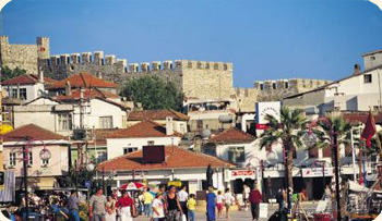
The marmaris Peninsula has always been an important part of the history of the mediterranean civilization with its strategic and geographic position also its natural beauty and rich past as a connection part of Aegean and Mediterranean. Marmaris and its around also was a host of many harbours and cities. Today’s big ships don’t need a port to take a shelter in against every storm. But the Mediterranean is still very generous to people living on her coasts. Nowadays numerous flights landed and departure at the Airport. Lots of tourists from abroad prefer to come here for their holidays.
 City where you can swim front of home door step: There is a wide range of accommodation of opportunities from small and cozy pensions to a wide selection of extra luxury holiday resorts and 5 star hotels for your holiday choice; many restaurants are serving best tastes of Chinese, French, Indian, Italian and Turkish cousin’s. Marmaris is a tourism and food center with its own Mediterranean style cuisine which is mix of natural herbs and various kind of fishes. City where you can swim front of home door step: There is a wide range of accommodation of opportunities from small and cozy pensions to a wide selection of extra luxury holiday resorts and 5 star hotels for your holiday choice; many restaurants are serving best tastes of Chinese, French, Indian, Italian and Turkish cousin’s. Marmaris is a tourism and food center with its own Mediterranean style cuisine which is mix of natural herbs and various kind of fishes.
As a result of water treatments and environmental planning’s, in Marmaris you can safely swim center of the town. Front of the hotels and at the other silent coves. Marmaris is one the unique place where you can swim at your home door step. The sand here has evolved from seashells and has a wonderful mild and tender texture, sandy beaches, small bays, small natural islands, interesting shape Rockies and 300 days sunshine all year around and clear blue sea.
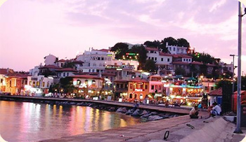
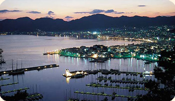
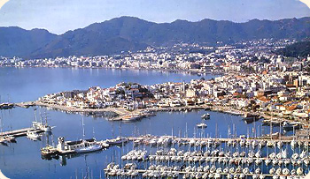
Marmaris is one of the most popular holiday resorts in Turkey. If you are travelling with your own vehicle, when following the road through the pine forests stop and take a break when you see the sign that reads,"İşte Marmaris" (Viola Marmaris). You will see the town from above. Although there has been a high level of construction in the town over the past 15 years, it still looks beautiful from this vantage point.
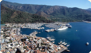
 Marmaris, with its population increasing to 100,000 in the summer months, is now a huge holiday resort city. The bed capacity of the hotels has surpassed 60,000 and it is possible to find hotels that will suit all types of budget. There are hundreds of restaurants, cafes and entertainment places newly opened up. Marmaris is one of the rare towns in Turkey where you can swim right in the city centre, despite the increased construction, as environmental and water treatment facilities have been installed. For those who seek cleaner seas and quieter spots there are boats trips that go to other coves or you can get there by land. If you are interested in water sports and nature activities the hotels and travel agencies here provide you with many alternatives. Marmaris, with its population increasing to 100,000 in the summer months, is now a huge holiday resort city. The bed capacity of the hotels has surpassed 60,000 and it is possible to find hotels that will suit all types of budget. There are hundreds of restaurants, cafes and entertainment places newly opened up. Marmaris is one of the rare towns in Turkey where you can swim right in the city centre, despite the increased construction, as environmental and water treatment facilities have been installed. For those who seek cleaner seas and quieter spots there are boats trips that go to other coves or you can get there by land. If you are interested in water sports and nature activities the hotels and travel agencies here provide you with many alternatives.
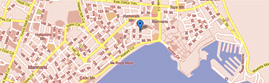
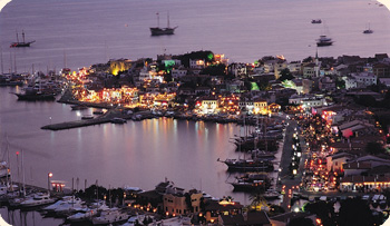
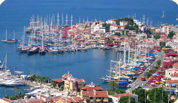
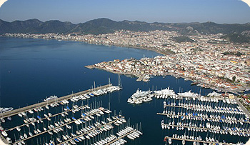
Marmaris Netsel Marina is biggest and modern Marina of Estaern Mediterranean both from a point of view is a great deal of concern about the direction the new owners would take the marina however with a change of management it appears that will once again gain its reputation as the “ best marina” at the Eastern Mediterranean.
 At the landing between Marina and (Çarşi) shopping center; there is a daily boat excursion. If you follow Venedik(Venezia) stream you will go to Bar Street. In that streets there is a many bars and clubs. Most of clubs are old traditional Marmaris houses, now they are serving for entertainments after restoration. Discos and bars are which come to life early in the evenings, surrounded by a lively atmosphere. Old town square is a kind of huge outdoor shopping center. At the landing between Marina and (Çarşi) shopping center; there is a daily boat excursion. If you follow Venedik(Venezia) stream you will go to Bar Street. In that streets there is a many bars and clubs. Most of clubs are old traditional Marmaris houses, now they are serving for entertainments after restoration. Discos and bars are which come to life early in the evenings, surrounded by a lively atmosphere. Old town square is a kind of huge outdoor shopping center.
Old bazaar is a maze of twisting little streets and alleys with white washed houses in the Turkish style amid an excellent shopping bazaar without traffic. You can find wide range of products.
Important Places:
Marmaris-Armutalan: Armutalan is a district of Marmaris. It is surrounded by woody hills with a beautiful wiew of seaç rapid growth of Armutalan last ten years, make Armutalan one of the most preferred part of Marmaris for tourists. There is a wide range of restaurants, hotels and apart for who would prefer silence. Armutalan is also famous residential area for retired people. Population is approximately 14.000.e resort and still preserved in its authentic features.
İçmeler: Situated on a bay, backed by rugged pine-clad mountains sloping down to beaches and clear blue sea. İçmeler spring water is a resource which was given its name to the town. This spring water is very healthy for digestive system. The accommodation in İçmeler is of a high standard and there are many restaurants of good quality to choose a mingling of modern and traditional lifestyles brings you the old village located behind the resort and still preserved in its authentic features.
 For the adventurous type there is a leisurely hike up through a beautiful canyon located behind the village that sweeps you into another world. Situated at the entrance to the resort is another feature that catches attention. İçmeler park; planned to resemble botanical garden, providing the visitors a world of nature only a few minutes from their hotel. Behind the park one of the best examples of art and literature are exhibited at the famous Art Street. For the adventurous type there is a leisurely hike up through a beautiful canyon located behind the village that sweeps you into another world. Situated at the entrance to the resort is another feature that catches attention. İçmeler park; planned to resemble botanical garden, providing the visitors a world of nature only a few minutes from their hotel. Behind the park one of the best examples of art and literature are exhibited at the famous Art Street.
Running through the center and slicing the resort in two parts is the stream of İçmeler. The delights of shopping are even more profound with the shops that follow the course of this stream.
Long-Beach: Uzunyalı has a beauty and feel that is many ways incredible. Marmaris one will see a long beach line backed by bars and hotels. As you continue to explore Marmaris you come across this strip of bars on Uzunyalı Marmaris. In winter times long beach is also mostly preferred by locals for walking and cycling. Long beach is stretches for 8km along the coast from Marmaris to center to İçmeler.
 Beldibi: Beldibi is a district of Marmaris located at the right side when you entering to the Marmaris, along green valley. Beldibi is a old place but last years show rapid growth for well construction. Ancient city physkos is also located at the Asar Hill just few minutes away from Beldibi. Until 1995 Beldibi locals were just dealing with vegetable growing and trading, but in recent years Beldibi is mostly preferred for foreign residence, according that teher is a big demand for construction business for locals. Beldibi is just 1km away from center of Marmaris. Population is 6000. Beldibi: Beldibi is a district of Marmaris located at the right side when you entering to the Marmaris, along green valley. Beldibi is a old place but last years show rapid growth for well construction. Ancient city physkos is also located at the Asar Hill just few minutes away from Beldibi. Until 1995 Beldibi locals were just dealing with vegetable growing and trading, but in recent years Beldibi is mostly preferred for foreign residence, according that teher is a big demand for construction business for locals. Beldibi is just 1km away from center of Marmaris. Population is 6000.
Recreation Areas Around Marmaris and Transportation Facilities:
Günnücek, Yalancı Boğaz,Cennet adası(Paradise Island)Nimara; it would be a nice change to give a break to the hot summer and spend a day in the forest on the seashore. You can go to Günnücek Picnic Area passing by Netsel Marina. There is a brook in that area, which supplies a special oil named sweet gum oil which is used in perfumery. This oil is known under several names, Oriental sweet gum oil or Turkish sweet gum oil. Diluted with suitable carrier oil, it is used externally for abrasions, anxiety, bronchitis, cataract, cough, cuts, ringworm, scabies, stress-related conditions and wounds.
How to produce Sweet gum Oil?
To obtain the balsam(boiled down sap) of sweetgum a long process must be undertaken. One way to obtain the balsam is by tapping the tree, similar to tapping for rubber or maple sap. The outher bark of the tree is removed the inner bark is striped off and thrown into pits until a sufficient quantity has been collected. It is then packed in strong, horse-hair bags and pressed in a wooden press. After removal hot water is thrown on the bags which are pressed a second time, when the greater part of the balsam will be extracted.
Nowadays there is an only one person who produces sweet gum oil, İsmet Baka is 73 years old and he dealing with this producing over 57 years. When he was in 16 years there were nearly 200 people who were dealing with produce of sweet gum oil and their production capacity was 150tones. But today he says “This business completely finished, only me still dealing, may be after I die nobody will produce sweet gum oil again in here.” One year production capacity is approximately 200kg sweet gum oil.
Aktaş: Located at the coast 3km away from Marmaris on the road of Yalancı Boğaz. North side is covered by forests and silent. It has nice sandy beach and has a best view of Marmaris. There is a few hotels can stay.
Adaağızı: When you continue from Aktaş after 2km you will arrive to Adaağızı. This is the best place of Marmaris for Water sport activities.
Yalancı Boğaz: Here is natural supporting wall along 800m, known as a yalancı Boğaz among locals. It connects Nimara Peninsula (Paradise Island) to a land. There are a shipyards.
Cennet Adası(Paradise İsland)
Paradise Island to the south of Marmaris, linked to the mainland by a causeway, was known as Nimera in ancient times and the remains of a monastery can still be seen. The island offers scenic beauty, fine beaches and views across the bay to Marmaris itself and its phosphorescent rocks in the caves reflect the blue of the sea, giving it its alternative name, Blue Cave.On the south of the island lies Aquarium Bay, a lunch stop for many of the boat trips and much loved by photographers for the unspoiled natural beauty and the unbelievable range of blues in the sea.
If you like you can go this island by minibus to Yalancı Boğaz then you can pass to the island by walk. There is a nice pathways and nice sea view. There is a nice restaurants and cafes at the sea side.
There is also another not widely-known cave inside of the island; you can go to this cave by short walk through bushes. There is no any sign for show exact place of the cave; you need a guide as well. Cave is very wide and full its wonderful display of stalactites and stalagmites.
Çamlık Landing Stage: One can arrive by road 12 km.from Mugla then by taking the turn at Çamlik village and driving a further 5 km. to the seaside and another half an hour journey by boat to the island. Also local agencies arrange daily tour to island.
Çamlı Village: Located at the 3km farther from Çamlık Landing stage and across to the Sedir Island. This is the place where ancient Karia city located. Boncuk Bay: Boncuk Cove The road from Çamli Köy reaches Boncuk 9kms further.Boncuk is one of the most popular coves of the region.Its waters are crystal clear and relaxing.There is a resort on the beach with regularly spaced palm trees.A very convenient cove for those seeking peace and quiet and who enjoy swimming among the rocks. An ancient ruin right next to the resort is attractive for history fans.
The area between Boncuk cove and Karaburun is the only known mating place of sandbar sharks where these sharks, that can reach up to 2m in length, can be observed. Diving tours may be arranged to observe and photograph these sharks especially in May and June.
Sedir Island Kedrai : Sedir Island is famous for the archaic city of Kedrai and the Cleopatra Beach.There are regular boat tours to the island from the Çamlik Pier.The boats leave once they are full any time of the day. Return is the same way.Its golden sand beach, shallow sea is especially suitable for families with children.
Karacasöğüt: Waterfall,Cave and Ancient Settlements: There is a junction at the 11th km of the Marmaris – Mugla road. The diverting road at the junction leads to the unique Gökova shores.The Karacasögüt Port is one of those not to be missed stopping points of the blue boat tours.Although the signs of a fire that destroyed a large part of the forest are still visible, it is still popular. To get to Karacasögüt Waterfall and Karacain Cave you will need to make a right 2–3 kms further on the way to Okluk bay from Karacasögüt.Ask the villagers around since there are no signs.
The waterfall drops from 25 meters. It has a natural pool below. The cave has two parts.Somalikaya Dudeni (Sink) and Suçikti Cave.One of the main entries to the caves is here.Only dinghies can move in the galleries of the cave. The cave is 421 m long and 15.5 wide. While accommodating two lakes, only 342 meters of the cave can be seen. Amateurs can go in to the cave only with guides and are should not go further than 10 m unaccompanied. Only 1 km of the Suçikti Cave, 1km west of Somalikaya Dudeni (Sink), has been explored by cavers. The cave and the waterfall have been declared as protected areas.
Works to open the cave to visitors are in progress. About 2kms southeast of Karacasögüt village on the Altinsivri Hill there are remains of the Ancient City Euthena.Those daring to climb the hill, which is 700 meters above sea level, will come to Karacasögüt village in the Ovacik neighborhood, the climb follows a narrow and steep path. Those not familiar with the area shoulkd ask for help from the villagers .The City Necropolis, whose walls remain, rock graves and cisterns can also be seen as you get closer to the hill. There are remains of the ancient period temple at the top of the hill and next to it the hut of the forest ranger if you are lucky there will be a glass of tea waiting to relax you. Euthena is believed to be a small city under Rhodes in the archaic period. There is another archaic city near Karacasögüt.Remains of the Ancient City of Amnistos are located on a promontory close to the village. Only the city wall remains from the ancient city and the old port wall exist today.
Around Marmaris (Turunç): (Seville Orange) If you are going to Turunç by bus or car, you will pass through a winding road between the pine trees. The climb begins after you pass Içmeler.If you are on the driver’s seat be careful of the winding road and do not get carried away by the beauty of the environs and Marmaris.If you are not into speeding, you can make the 20 km asphalt road in half an hour.But if you like you can take the 15 mile sea road. However you get there, go to Turunç.If you are staying in Marmaris, take a day off from the big city like atmosphere of Marmaris.
 Uphill, downhill, winding roads with the pines always next to you, Turunç will pop up in front of you suddenly. Below there is a sea almost as if dyed with a special shade of blue.Indigo and clear blues, with the reflection of the sky on the sea; all shades of blue can be seen in it. A coolness falls from the hills surrounded by high hills of pines; the sun is always bright but never suffocating. Pomegranates, mulberries, figs, plums,carobs,and ofcourse Seville oranges. Turunç Municipality is planting Seville orange trees in the region, named after these trees and which have decreased in numbers in the recent years. Moreover, the colorful geraniums, oleanders, begonville’s are everywhere. Uphill, downhill, winding roads with the pines always next to you, Turunç will pop up in front of you suddenly. Below there is a sea almost as if dyed with a special shade of blue.Indigo and clear blues, with the reflection of the sky on the sea; all shades of blue can be seen in it. A coolness falls from the hills surrounded by high hills of pines; the sun is always bright but never suffocating. Pomegranates, mulberries, figs, plums,carobs,and ofcourse Seville oranges. Turunç Municipality is planting Seville orange trees in the region, named after these trees and which have decreased in numbers in the recent years. Moreover, the colorful geraniums, oleanders, begonville’s are everywhere.
A district in Marmaris. It is one of the 5 municipalities in Marmaris. Turunç is 20 km away by land and 15 miles by sea. It can be reached in half of an hour using the asphalt but through a curvy road crossing the forest in Içmeler. Turunç is one of the very popular stopping points for blue cruise boats. When evening falls, songs are heard from restaurants on the shore and boats anchored in the bay.
Also, “Blue Flags” are swaying in the Turunç bay, just like in Marmaris and Içmeler. The Blue Flag is put up by an international organization to coves with clean water, sand and environment and which have the necessary infrastructure for yachts. There are options other than the sea and sun in Turunç those interested in a walk in nature and jeep safari tours will find accommodating routes.
For hiking the Palamut hill path and the 3-4 hour long scenic walking trail that used to connect Turunç and Içmeler before there was a road may be considered. The water is very clear for diving and observing the underwater life.The Rocks are also rich with underwater caves. There are operators organizing water sports on the bay.Only boat free water sports are allowed to avoid noise pollution.
 You can rent all the equipment you need and there is also training available if desired. You can take a daily boat tour to the neighboring coves. Coves and beaches such as Kumlubük, Çiftlik and Gebekse are included in the trip.You can go to Dalyan and Iztuzu beach through an extended daily boat tour.You can rent a private boat and plan your own trip. You can also fish in the cove. Let us note that the fish are especially plentiful between October and April. You can rent all the equipment you need and there is also training available if desired. You can take a daily boat tour to the neighboring coves. Coves and beaches such as Kumlubük, Çiftlik and Gebekse are included in the trip.You can go to Dalyan and Iztuzu beach through an extended daily boat tour.You can rent a private boat and plan your own trip. You can also fish in the cove. Let us note that the fish are especially plentiful between October and April.
Kumlubük is famous for its restaurants as well as its beach. Kumlubük may be reached by land from Turunç, where you can find the regions tastiest and best-cooked seafood.The scenery is impressive.Kumlubük shore and hills have the best tracks for nature walks and eco-tours. It can be done in the heat of the summer but the best time for this are the other seasons. The cave which is reached when walked towards southeast from the Kumlubük shore dazzles everyone. It is believed that 5 thousand years ago this cave witnessed the first settlement. Its entrance is about 4 meters. There are galleries, stalactite and stalagmite inside. Since it has just been explored there has not been any scientific research done yet. Just like the Paradise Island cave.
Bayir is one of the favorite stops of recent, “safari” tours. Do not forget to have tea or a frothy yoghurt drink (ayran) under the shade of the big, historical plane tree at the village square. Those who are hungry can also order gözleme ( a thin börek cooked on sheet).The rumor is that walking once around the old plane tree prolongs life. Habitants of Bayir have written this on the identity disc of the plane tree.
The icy water of the square’s fountain will refresh and relieve you. It is claimed that the Bayir village is founded on the ancient city of Syrna and there was a temple dedicated to Aslepios, God of Health, in place of the mosque today. There are almost no remains left from the the temple.The acropolis of the city of Syrna in on Yancagiz Hill, 2kms northeast of the village.
The acropolis may be reached from Bayir, through the ancient stone road which is still used. The climb takes about half an hour.You will see a part of the city walls, tomb cover stones and structure remains in the acropolis.The ancient stones in the Bayir cemetery are most probably from the city of Syrna.
The road divides into two after Bayir. One goes down to Turgut village from the right. The other one heads towards Bozburun. We will take the Bozburun road first and turn to Çiftlikköy 1km further down.We leave descending to Orhaniye and Selimiye via Turgut for later.
Çiftlik be careful not to miss the Çiftlik fork about 1km further down on the asphalt road from Bayir up to Sögüt.There is a hardly visible sign.After the fork, there is a short plane than the descend to Çiftlik cove begins.Rest for a while and fill your lungs with the clean mountain air where you can see Çiftlik cove on one side and Hisarönü cove behind.All around there are pine forests. The road down to Çiftlik is a winding one. You are at the beach 15 minutes later. Çiftlik cove’s coarse sand beach is popular. There are not many beaches like this in Marmaris and the surrounding coves.
We must add that the sea is always crystal clear.Let yourself float on the cool water.Swim for as long as you want and then stretch yourself out on the sand.The beach surrounding the cove is not really crowded other than in the lunch hours when daily boat tours from Marmaris stop by. Yet, Çiftlik cove is not as peaceful as it used to be. A summer house complex, two hotels, one bigger than the other, and a facility providing water sports are some of the possibilities one may find at the cove. A half built holiday village with only its restaurants and entertainment facilities completed, and the intense traffic of the beachside restaurants, can be felt. There is a small island at the entrance to Çiftlik cove.
The island is private property and cannot be accessed without permission. Let us remind you that the rocks on either side of the cove are suitable for diving but now its very difficult to find fish and go spear fishing.You may go to the nearby Gebekse cove to dive or to swim. You will ruins on the beach at the far end of this cove.It is believed that the Gebekse ruins are that of a church.
The Gebekse cove is among the preferred places for blue cruise boats to spend the night in. A small number of daily boats also stop by.Gebekse cove has a small beach and a beachside restaurant.You will enjoy diving with goggles and watching the thousand and one colors in the under waters.
Selale (Waterfall) : We return once more to Bayir village. This time we head downwards towards the Turgut village. You will see the “Selale” (waterfall) sign 5.5 km further from Bayir.It is possible to drive to “Selale” which is 200m in from the road. “Selale” is not one of the majestic waterfalls we know. It was formed by a brook,which flows through thick plants and looses its waters significantly in the summer months, flowing down from 3-4 meters. The brook’s water is ice cold.If you have your swimming gear with you, you may swim in the pond created by the waterfall which is about 2-3 meters deep, chill out from the suffocating heat for a while.There are beachside restaurants around and near the waterfall.
The gözleme (a thin börek cooked on sheet) are cooked in front of your eyes by the village women, the ice cold ayran (yoghurt drink) will make you feel good after an ice cold shower. If you wish you can also order trout, meat or chicken. If you can spare the time, you can walk by the brook and into the valley. Do not forget however that the thick layer of plants can sometimes make walking very difficult.
Turgut 9km away from Bayir, has just started to develop because of tourism. The Carpet and gift shops provide liveliness in the village where tourists come in groups to shop. There are many decent restaurants at the entrance to Turgut. The carpeting in Turgut village, one of the must stops for those taking the jeep safari tours, competes with the activities of big cities.
Most of the people working in export shops where carpets made all around Turkey are displayed and sold deal with production. The visitors that come for shopping see how a carpet is weaved as well as how the wool is turned into thread and dyed with madder. They watch with interest as the silk thread used in weaving the carpets is made from the cocoons thrown in a cauldron full of water.Village food is also available in the restaurants in Turgut as well as sea food, which attracts tourists with its beach, silk and wool carpets.
Peanuts are one of the major products the villagers of Turgut have alongside of tourism, apiculture, fishing, raising livestock and agriculture. Remains of the archaic period attract the attention in one of the coves within the Turgut village borders. Remains can be seen on a garden wall at the seashore and further inside, on the Temenos wall which is thought to be surrounding the holy Ygeia area. Those remains are believed to belong to the ancient city of Hygassos.On the road to the waterfall from the village center, about 1km on the right slope, there is an ancient construction, not easily noticed. A short time ago archeologists determined that this was the mausoleum of a warrior named Diagoras, circa BC 3-4th century
Turgut Fort (Bybassos) : There are stands the Turgut Fort on a hill of approximately 300 meters near the Turgut village. It is possible to drive on the dirt road up to about 300 meters near the fort.The second very steep part must be reached on foot.The walls of the fort believed to belong to the ancient city of Bybassos are still there although collapsed. The exciting part of climbing the fort is the amazing scenery that shows the Orhaniye and Hisarönü coves.
Orhaniye and Kizkumu : Orhaniye is only 2.5km away from Turgut.The road divides in two after Turgut.The road to the right leads to Orhaniye and the road to the left to Selimiye. One of the important tourism centers in the Hisarönü Bay is Orhaniye.Yachts visiting the Hisarönü Bay always spend a night in Orhaniye. The sea is always very still in Orhaniye. The shade of the pine forest falls on the seas painting the sea a color unique to this place. It is so peaceful that you can only hear the noises made whilst swimming. You will see people walking in the middle of the sea.
You will be surprised. As a result of the sand dune movements a high stripe of sand is formed starting from the land, dividing the bay in two. This strip, about 600m long, is called Kizkumu. There is also a legend: “The girl who wanted to meet her lover filled her skirt with sand, and walked filling the sea with the sand in her skirt. But she ran out of sand and drowned at the end this path standing in the middle of the sea.”There is an island in the middle of the bay with the remains of a castle on top of it.
The fort is believed to belong to ancient city of Bybassos,which was established in that region. You can reach the island by renting a small boat and go up to the fort ruins following the path. The view is amazing. It will be worth your efforts. The people of Bybassos carried water to the fort by aqueducts and under water pipes from the waterfall. They have made use of the Laplace’s law.There are also boat tours from Orhaniye to Hisarönü bay. Stops are made at coves like Selimiye, Hisarönü and Inbükü and Dislice Island.The tour lasts until the evening and includes lunch. Dislice Island on the Hisarönü bay is interesting with its small canyons and rock formation.
There are the ruins of a monastery near the Marti Marina and Hotel complex at Keçibükü, at the entrance of Orhaniye cove, where yachts drop anchor and get maintenance summer or winter. The mosaics in the garden are worth seeing. It is possible to get on the Hisarönü and Marmaris-Datça road from Orhaniye.
The distance between Orhaniye-Hisarönü is only 3.5km and has a wide asphalt road. Those wishing to stay in Orhaniye may stay at boutique hotels as well as modest places. How to get there; We came to Orhaniye via Bayir. But those wishing to get there directly can use the wide and comfortable Hisarönü road.To do that you need to turn into the Datça road from Marmaris and turn left at the Hisarönü-Bozburun turnoff (You can reach Turgut and Selale the same way).
Selimiye : We go towards Bozburun from Orhaniye, following the shore.The road is wide asphalt.We are in Selimiye 10kms after Orhaniye and 7kms after the Turgut turn.Selimiye is one of the stopping points of blue cruise boats that cruise between Bodrum and Marmaris. The village is very green. The sea is clean and usually calm but there is not much of a beach.There are small but good restaurants gathered around the pier, providing service to boats and those that come from around. They have fresh fish on their menu.There is an indefinite peace ruling the environment. Something to note for these wishing to have a holiday away from the crowds. You can also find historic ruins around Selimiye.
There are remains of three castles around Selimiye which was called Hydas in antiquity. On is on the highest hill of Selimiye, another on Sarikaya hill and the last one is Asarkale in the Kizilköy neighborhood.To the southeast of the bay Hellenistic age city wall remains are to be found. The watch tower, light house, 100 meters off the shore, built in order to guide the ships nearing Selimiye and the monastery and the theater are other interesting ruins worth seeing.
The remains excavated from the sunken ships in the region are on display at the Bodrum Underwater Museum. If you are looking for a beach on Selimiye where the boats hide during stormy weather because it is a natural harbor, you can go to the “shallow harbor” 2kms further with glittering sand.There are hotels and pensions to spend the night. What to eat? There are many restaurants in Selimiye around the piers where the yachts drop anchor.Fish is plentiful. They cook it grilled or steamed, depending on the type of fish.
Pure olive oil and laurel leaves add a different flavor to steamed fish.Stuffed coquette flower is a specialty of Aegean kitchen.Boat tour Kamelya and Dislice Islands Daily boat tours to nearby bays and islands are available from Selimiye.
The first stop is the Kamelya Island, after a 45 minute trip, just like from Orhaniye.There is a monastery on the island which is easy to climb to.Black, white and gray sea stone mosaics decorate the base of the monastery.
Another stopping point is the Dislice Island, where boats leaving from Orhaniye also stop at.The island has volcanic rocks with a monumental look.The rocks are so formed that the island is very convenient for lovers looking for a place to be alone, hence its name, “Island of love”.The back side of the island facing the Bencik cove has small beaches.
Bozburun : Mostly yachters know Bozburun.Bozburun is one of the most secluded places of the region from the view of tourism.This place recommended for people who are after a peaceful, relaxing vacation.There are not any large tourist facilities, they are small but good.Bozburun is in one of the bays of the Sömbeki Bay.The environment can be considered as quite naked compared to other regions of Marmaris.There are small motels, pensions and good fish restaurants in the village.It is said that this is where the best schooners are made.
There are many calm bays around it that can be reached by boat.There are boat tours from Bozburun pier to surrounding cove and small islands.There are the not so significant remains of Larymna settlement on the Asar hill near Bozburun.To climb up the hill takes about 45 minutes.Parts of the city wall and tomb remains are scattered around the area.
Bozburun looks pretty from the hill. How to get there There are two ways to get to Bozburun from Marmaris.The first option which takes about 45 minutes is to get to the Datça road then to follow the shore road, from the Hisarönü turnoff.Hisarönü, Orhaniye, Selimiye are the settlements on this road.You can also reach Bozburun by heading south via Içmeler-Bayir.The 24km winding road after Bayir passes through the Sögüt village.There are regular minibus rounds between Bozburun-Marmaris.
Sögüt and Saranda : Sögüt village may be reached from Bozburun or from Bayir village.Sögüt village is a bit of a out of the way and at the end of Bozburun peninsula.Therefore it has been left out of the tourism traffic to a great extent. Yet the village market is quite lively.The villagers are aware of tourism, and then try to help, and they show an interest. 1km to the southwest of Sögüt village,on the hill a little behind the school there are ruins of the Thyssanos settlement.The ruins in the unexcavated city, the ruins consist of a few pieces of wall,signs of foundations and the remains of a wall at the back of the hill. The village is inland from the sea.Sögüt’s door opening to the sea is the Saranda bay.
A striking view will greet you as you descend to Saranda, 3kms from Sögüt.Sömbeki bay and the green Saranda bay is under your feet.The big island covered in mist in the distance is the Greek Island of Sömbeki (Simi).Indulge in the scenery especially at sunset.Saranda is the newly explored center of tourism in the region.
The single storey stone and briquette house of the Saranda villagers are turning into summer houses with pools and gardens and boutique hotels under their new owners.People from various nations who have decided to live in Marmaris are buying houses in this region.The organic agriculture in the gardens is effective in attracting people who enjoy organic food.
What to eat, where to stay? Saranda is among the unique place not yet discovered.There are restaurants around the pier.Prices are reasonable.The mezes (appetizer dishes) prepared from the village grown produce as well as the sea food are very tasty.it lacks comfort but it is clean.As well as the village pensions there are single storey villas with pool-gardens that can be rented for a night or for a longer period.
Taslica It is approximately 5kms from Sögüt to Taslica.The road is narrow but it is asphalt.The first one kilometer part has extraordinary scenery.Saranda beach, coves, promontory and the islands form an impressive view.Be careful driving. Ruins of the Carian city Phoiniz are 4kms out of Taslica on and around Asar hill.First you see the tombs on the path, which is probably from the archaic times, between the village and the ancient settlement.
More or less around the middle of Taslica and Asar hill, there is the agora of the city in the hole, and then climbing up the hill you see the remains of a structure in rather good shape and then the city’s main necropolis (tombs).The acropolis of the city is in Asar hill.The view dominating the surroundings is more interesting than the ruins on the hill.The sea on the one side, the vacant and about to collapse houses of Sindili village deserted in the 1950’s on the other, Aziziye neighborhood of Taslica near Serçe pier 6km further in the southwest can be seen from the hill.
Serçe Pier The road turning right while entering Taslica leads you to a beautiful pier; Serçe pier.The pier offering a gleaming bottom, where Blue Cruise ships drop anchor is protected even in the harshest weather conditions.During an underwater research project glass ornaments were discovered in a sunken ship from the 11th century and these pieces were sent to the Bodrum Underwater Museum.Serçe pier is known as the place of these archeological finds.It is noted that Kasara city was also established here yet there are no findings related to the city.
Taslica, Kirkkuyular on the first kilometer of the Serçe road, and little further ahead the ruined stone houses of the deserted Sindilli village can be seen.Kirkkuyular takes its name from the 40 cisterns are still used for raising livestock, agriculture and for use at homes, in the barren area that has water problems.Kirkkuyular and Sindilli is the new address for village and trekking tours.
Bozukkale (Loryma) : If you want to reach Bozukkale pier and the nearby Loryma ancient city remains by land you have to drive from Sögüt to Taslica, then walk.Bozukkale pier is one of the important stopping points of blue cruise ships and yatchs with its position that provides protection from the wind.The bay had strategic importance in history as well because of this position.The fleet of Athens had stayed here in BC 1412, and recovered here again before the Knidos naval war in BC 395. There are restaurants serving blue cruise ships and yachts at the cove.Ruins of the Loryma Archaic city established in BC 7th century are spread across a wide area including the cove.The 120 meter long, 10 meter wide harbor fort in rather good condition is the most important ruin that reached our day from the city that was deseted completely after the Arab invasion in the seventh century.
The fort that was under the rule of Rhodes and which was strategically important for the protection of the Union of Rhodes was deserted in time. There is an acropolis that can be reached by a 1 hour walk on the upper part of the city,on Karaburun.The three large cisterns on the acropolis, surrounded by walls and remains of a foundation belonging to one single structure show that this area was used for shelter at times of danger.Three churches and many houses were built in Loryma using the archaic time material which was used as a naval base and armony during Byzantine times.The houses are on terraces on the slope which are built with care.In the grassy plain to the west of the city there is the holy place of “Artemis Soteria.”The necropolis on the west reaching south is adjacent to the temple.In the grassy plain to the south of the necropolisis the holy area of Apollo. Moreover, it is known from the inscriptions that there is an altar dedicated to the Rhodes God, Zeus Atabyrios.
Kiran Lake : A small lake with a diameter of 30 meters, which fills up in the winter and dries out in the summer, next to the Loryma (Bozukkale) archaic city.As it is understood from the present day remains that like the other ancient cities around it there was a historical city under Rhodes next to this small lake.Since the location of the city is not easily accessible by land, you can reach the archaic area by first going to Bozukkale Pier by sea and then after a hard 2 hour long walk.Since there have not been any excavations yet, there is not sufficient information about the area.
The most pleasant part of the Marmaris-Datça road, which is narrow and winding, is that which gets to the highest point and from where you can see the scenic view of the Hisarönü on one side and on the other the Gulf of Gökova. Shortly you will go downhill and get to coves that compete with each other in beauty. Turning left off the Datça road after 22 kilometres onto the Bozburun road, and after driving one kilometer more, you will get to the village of Hisarönü, which lies on the edge of the gulf that it is named after. The village is a bit off the main road. Hisarönü has shallow waters and red coloured sand and is an option for those who want a quite and calm holiday away from the Marmaris crowds.
It is known that the air of Hisarönü, which is non-humid and always has a breeze, and its clean waters are good for those suffering from asthma and heart diseases. Between the village and the gulf on the flat region called Pazarlık (or Gavur) on Eren Mountain there are the ruins of a small temple. The ruins are those of the Temple of Hemithea. Diodoros, an ancient historian from Sicily, said that the Molpadia (singer) was brought to the region by the God Apollon. The woman singer was worshiped as a demi-deity (Hemithea) and a temple erected to her. He said that the fame of the temple lasted for a long time. The small city of Kastabos was linked to the ancient city of Baybassos. The ruins of Baybassos are one or two kilometres to the north of the temple on the hill between the Marmaris-Bozburun road and the sea. The Middle Ages castle is in good condition.
Twenty nine kilometres along the Marmaris-Datça road you turn to the right onto a dirt road. This leads to the Gulf of Gökova and to the incomparable beauties of the gulf and Börbüdet Cove. On the road you will find many beautiful small coves that invite you to get out of your car and go for a swim. However, resist the temptation. If you are patient you will come to even more beautiful places.
The trip is nine kilometres, during which you will come across strange signs such "Radar control max 120 km" while you travel at a top sped of 20 kilometres on a rough road. Then another sign tells you that you can not make a U turn. Every kilometre you drive you will pass signs that seem to be a joke. Then finally there is a sign saying "The End". Now you are at Börbüdet Cove.
Borbüdet Cove is one of the most virginal and beautiful in the area. There is only one hotel and camping area in the area. These facilities are run by people that take great care of the environment. Amazon Camping provides services to yachts. They are ready to help seafarers who are in trouble and need urgent help. The radio code for it is Amazon 16th Channel. Those who come on one of the daily trips can enjoy the food services.
The cove and the area are under a first degree natural protection order and all types of construction work is banned. We hope that no one comes around to find a loophole in the laws and the area stays as it is. A stream enters the cove and yachts can go a short way up it, while small boats can go deep into the waterway. It is a natural port and a secure shelter in storms. The area around is forest and if you want to walk get onto one of the paths where you can only hear the sound of birds.
The Çubucak and İnbükü Forest Camps : Twenty kilometres along the Marmaris Datça road there is the Çubucak Inner Forest Camping Area. Three kilometers further on, on your left you see a beautiful cove surrounded by pine trees below a ravine. The entrance is bit further up and you can drive all the way to the seaside. A further five kilometres along the road you will another forest camping ground that is called İnbükü. These coves, with their clean air, crystal clear seas and quite coolness, are beautiful stopping points those who travel to Datça by car. You can take your food with you and spend a day away from the crowds. In the Inbükü Forest Camping area there is a buffet where you can buy something to eat.
We would especially advise the Inegöl type meatballs. You can also get fish, meat and chicken, all cooked over a wood fire. At the entrance to the camping ground you pay a little money for persons and vehicles. At Emel Sayın Cove, locally named after the prominent Turkish singer, you can camp, park a caravan or pitch a tent. In the morning you can get on the motorboats that give a day cruising tour in the vicinity. The tours starts at 10:00 am and ends at 18:00 pm. You can bring your own food or not according to your wishes.
Bencik Pier : Bencik Pier, one of the most preferred coves on the Gulf of Hisarönü by yachts, is at the narrowest point of the Datça Peninsula. On one side is Hisarönü and on the other is the Gulf of Gökova. From Bencik Pier you can walk to the entrance of Börbüdet Cove in 20 minutes. On the shores of Becnik Pier there is the summer facilities of a state institution. The road that passes along the shore leads to the five-star hotel.
Between Marmaris-Datça : In the area after this point on the Datça road the green diminishes. You get out of the forest and the region becomes more barren. However, in compensation the sea is so beautiful and so are the beaches.The Aktur holiday site, where numerous famous people have houses, is one of them. The settlements on the shores near the village of Emecik are of the same nature. |